Acton Beauchamp in its Historical Setting
We are fortunate in Acton Beauchamp to have documentary evidence of the history of the parish, and to have had a former resident Dr CWM Pratt who studied these documents in depth. His findings were published in the Transactions of the Woolhope Naturalists’ Field Club.
Bronze age flints have been found, and lynchets (earth terraces on sloping land) in the area near the present-day church, are evidence of ancient farming. The various old names of Acton relate to oaks suggesting that the area was originally heavily wooded.
The Romans were here, specifically near the present Church: there is evidence of a Roman road leading East to Halfridge and Romano- British pottery (Severn Valley Ware) has been found.
The Saxon charter of 716AD records that Acton was given to St Mary’s Abbey in Evesham by King Aethelbald, and a record of 727AD records that it was then given to Buca to “strongly hold and defend and keep diligently and provide an everlasting dwelling of God’s servants” ie a monastery. The associated fishponds can still be seen below the church.
In 972AD King Edward gave a charter to the monks of Pershore Abbey confirming their land and privileges including those in Acton. This contained the first formal recording of the boundaries of Acton Beauchamp. These boundaries were very important as they came to determine the western limit of the Hwiccan kingdom, the diocese of Worcester and later Worcestershire, and the border had to be held against the Magonsete.
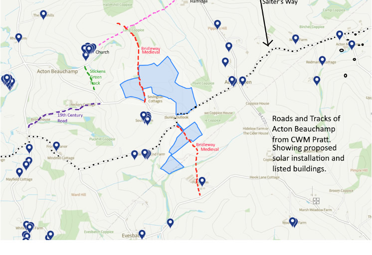
This same boundary charter refers to the Salter’s Way which crosses Acton on its way from Droitwich to Hereford (Suckley to Bishops Frome). See map.
The path enters Acton from Suckley through what is now Acton Green, takes the left turn at Sunny Outlook, past Sinton’s End and Kidley, right turn past Frome Manor, then left to Bishops Frome.
Priests passing through Acton on their way between Worcester and the monastery also used part of the Salter’s Way before turning down towards the monastery on the Paunton Road, and taking the Stickens Green Track which was the route at that time.
Droitwich was the principal source of salt in the Midlands from the 8th Century onwards. Rights to the salt pits were shared and holders included the Abbey of Evesham, the Church of Worcester and at the time of the Conquest Urse D’Abitot, Sheriff of Worcester, all being sometime owners of Acton. There was a two-way trade because wood was required for the salt workings, which may account for some loss of woodland in Acton.
Before the Conquest the manor was disputed between the churches of Worcester and Pershore and both of them altered and forged documents to support their claims. According to the Domesday Survey Acton had belonged to the church of St. Mary of Evesham in the reign of Edward the Confessor, and Urse received it afterwards from the abbot in exchange for some other land. In 1086, however, Urse held it for Odo, who was the Bishop of Bayeux (who probably commissioned the famous tapestry and was half-brother of William I), and the manor was still held of the fee of the Bishop of Bayeux in the 12th century. But in 1298 and 1316 it was said to be held for the Abbot of Evesham.
Acton was a single estate in Saxon times and continued so through the Norman era through to the 17th century usually with an absentee landlord.
There is evidence of a deserted medieval village near the church, which itself had been built by 1280 (Lay Subsidy Roll), and incorporated an Anglo-Saxon carved cross shaft used as a lintel for the tower.
In the Middle Ages a North-South pathway appeared connecting the main East-West route through Acton, to the more Northern East-West Church to Halfridge route. This ancient route is the current bridleway which would pass between fields two and three of the proposed solar installation. The North-South Ridgeway route to Worcester (current B4220) also appeared in the Middle Ages, crossing the Salter’s Way at present day Acton Green.
In 1594 a manorial survey was carried out prior to a sale in 1602 and as a result we know the names of the people who lived on our plots before us. We know where the open fields were, and that these were slowly being enclosed. Not all the field names have survived but many have and can be identified on the 1839 tithe map
A number of the dwellings had disappeared by 1839 but traces of some, such as Kyouse or Gatehouse) on the bridleway are still visible, and at Yagtree were until two years ago.
Other entries of particular interest in the current context include
- Shipman’s Place, later Longerlands, lying immediately to the south of the Salter’s Way. In time, the holding was absorbed into Sevington, Sintons End and the Green, but its fields had included two horse crofts, now the location of the Designated Wildlife Site, Horse Croft Meadow. The current home associated with this historic location, Sunny Outlook, is 36m from the proposed solar installation, actually a noisy and unsightly permanent electricity grid connection sub-station. The Wildlife Site itself would be enclosed on two sides by solar panels.
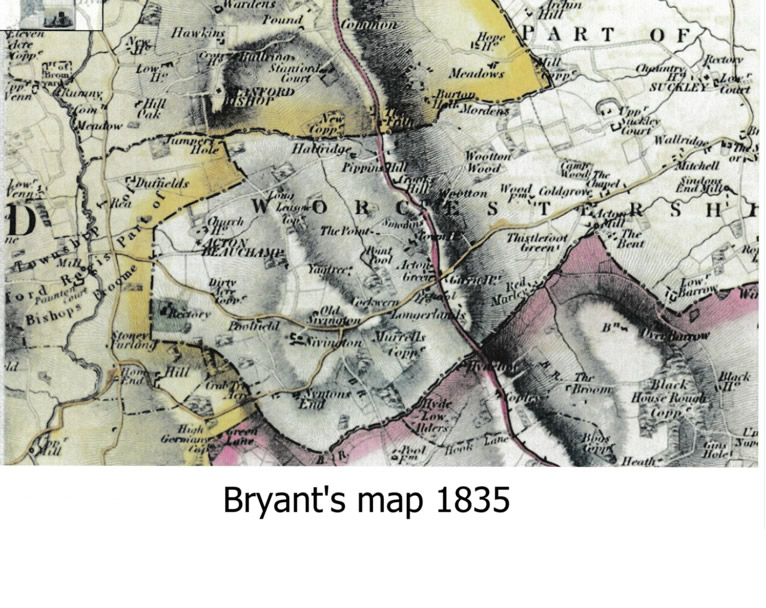
- In 1594 Sevington’s Hall, with its holding of 43 acres, was located in the vicinity of what is now Sevington Cottages, where there is also an older barn and fold. On Bryants map of 1835 Old Sivington is shown in that location. Sevington’s Hall was sold in 1625 and the current Sevington Farm was built about 1645 in a lower location about a quarter of a mile south, on the other side of the East-west track through Acton. Part of Manor Barn may have predated the new house as it has been identified as medieval. This ancient building is only 160m from the nearest point of the proposed solar installation.
- Sevington Cottages (built in about 1880) is 35 m from the proposed solar panels in Field 3. In HCCs response to a planning application in 2008 these farmworkers cottages were described as a non-designated heritage asset of interest, part of the Sevington Farm estate.
- Sintons End Farm, unnamed in the Tudor Manorial Survey, dating from and adjacent to the Salter’s Way. It is possible that the ‘end’ in its later name indicates a small hamlet. 230m from the proposed solar installation.
- Kydlawes Place (Kidleys 1839) – there’s been a house on this site since 1280 – lies adjacent to the Salters Way and would be 345m from the solar installation.
There are many other beautiful listed buildings in the close vicinity of the proposed installation, some included in the manorial survey, and some part of the later history of the parish, whose settings would be deeply affected by the proposed solar installation. You can see an easily searched map of them at Search the List: Map Search | Historic England.
The setting of the heritage groupings at Sevington, and Sintons End would be the worst affected, but many others, including those at Acton Green, would also be affected by visual effects and suffer the enormous disruption and damage from heavy construction traffic in the narrow lanes.
In the 13th century Acton passed to the Beauchamp family, and that is how it got its current name. We must make sure that it continues to keep its beautiful fields.


The Charter Bounds of Acton Beauchamp, CWM Pratt, Woolhope NFC 49 1997
A History of the Roads and Tracks of Acton Beauchamp, CMW Pratt, Bromyard and District Local History Society Journal 27 2005
An Interpretation of a Tudor Manorial Survey of Acton Beauchamp, with Reference to the History of the Landscape, CWM Pratt, Woolhope NFC 50 2001
Tithe map of Acton Beauchamp 1839


